Support to our research projects has been extended through the use of GIS software.
Where relevant it is possible to create a database for any aspect of our research and to relate our findings/obsevations to a specific point, line or area through the addition of National Grid coordinates.
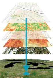
The specific database content can be loaded into QGIS and overlayed on published background maps or other layers derived from our research.
These maps can be prepared so they can be shared on our website.
Data from external research on any aspect of history in Bedfordshire can be included.
| Map No. | Description | LInk |
|---|---|---|
| SHARNBROOK MAPS | ||
| 1 | All excavations sites by Project | Location sites |
| 2 | Pottery Distribution by Type | Pottery Distribution |
| 3 | Slag Distribution (graduated by weight) | Slag sites |
| 4 | Clay Pipe Distribution (graduated by number) | Clay Pipe |
| 5 | 1925 Rate Evaluation ( graduated by RV in pounds) | Rateable Values |
| 6 | War Memories | Wartime Memories |
| 7 | Monuments by Number | Church Monuments by Number |
| 8 | Monuments by Name | Church Monuments by Name |
| 9 | HER Listed Buildings | HER Listed Buildings |
| 10 | HER Monuments and NMP programme | HER Monuments and NMP features |
| 11 | Enclosure 1810 | Enclosure Ownership & Farms |
| 12 | Pre and Post Enclosure maps | Pre- and Post-Enclosure |
| 13 | Sharnbrook Open Fields | Open Fields 1617 |
| 14 | Sharnbrook Fields | Sharnbrook Fields |
| 15 | Sharnbrook Arable & Pasture in 1855 | Field Usage 1855 |
| 16 | Sharnbrook Lidar | Sharnbrook Lidar |
| BEDFORDSHIRE - DOMESDAY | ||
| 17 | Number of Holdings for each vill in Bedfordshire which were included in the Domesday Inquest 1086 | Number of Holdings in a Vill |
| 18 | Manor Types (M or D) in each vill | Manor Type |
| 19 | All Bedfordshire Holdings held by Sharnbrook's Tenants in Chief | All County Holdings by TiC |
| 20 | The extent of Woodland | Woodland distribution |
| 21 | The extent of Meadows | Meadow distribution |
| 22 | Number of Mills | Mills by Number |
| 23 | Amount of Total PloughLand | Total Ploughlands by acre |
| 24 | Amount of PloughLand owned by King | King's Ploughlands by acre |
| 25 | Amount of PloughLand owned by Church | Church Ploughlands by percent |
| 26 | Change in Value of Vill at 1086 after 20 yr of Norman ownership | Value 1086/1066 |
| 27 | Value of Vill in 1086 | Value in 1086 |
| 28 | Ownership by Religious Houses plus support for Ramsey in both 1066 and 1086 | Vills owned by Religious Houses |
| OTHER BEDFORDSHIRE or WILLEY HUNDRED PARAMETERS | ||
| 29 | Number of ENDS | Vills with Ends |
| 30 | Number of Hearths circa 1670 (Data D. Jamieson, Willington) | Number of Hearths per vill 1670 |
| 31 | Medieval Settlement Types (Data: Prof C Lewis et al) | Medieval Settlement Types |
| 32 | Date of Acts of Enclosure | Enclosure Acts |
| 33 | Percent of land enclosed | Percent of land enclosed |
| 34 | Ancient Furlongs Data: HER | Ancient Furlongs |
| 35 | 1332 Taxation | 1332 Taxation |
| 36 | 1798 Taxation | 1798 Taxation |
| 37 | Remaining Ridge & Furrow 1990-2015 (Data: M Tuohy et al) | Ridge & Furrow |
| REGIONAL PARAMETERS | ||
| 38 | HEFA Excavations in East Anglia (Data: Prof C Lewis) | HEFA excavations in East Anglia |
| 39 | Star Chamber (Data: Helen Good) | Star Chamber |
| 40 | Manorialisation Factors 1 & 2 (Data: J Kanzaka) | Manorialisation |
| 41 | Manorialisation Factors 1 & 3 (Data: J Kanzaka) | Manorialisation (tenements) |